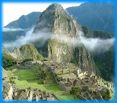
| Machu Picchu is a pre-Columbian Inca site located 2,430 metres (8,000 ft) above sea level. It is situated on a mountain ridge above the Urubamba Valley in Peru, which is 80 kilometres (50 mi) northwest of Cuzco and through which the Urubamba River flows. The river is a partially navigable headwater of the Amazon River. Often referred to as "The Lost City of the Incas", Machu Picchu is one of the most familiar symbols of the Inca Empire. The location of the city was a military secret, and its deep precipices and mountains provide excellent natural defenses. The Inca Bridge, an Inca rope bridge, across the Urubamba River in the Pongo de Mainique, provided a secret entrance for the Inca army. Another Inca bridge to the west of Machu Picchu, the tree-trunk bridge, at a location where a gap occurs in the cliff that measures 6 metres (20 ft), could be bridged by two tree trunks.
Machu Picchu is 80 kilometers northwest of Cusco, on the crest of the mountain Machu Picchu, located about 2,450 meters (7,710 feet) above sea level, that is around 1,000 m lower than Cusco. As such, it had a milder climate than the Inca capital. It is one of the most important archaeological sites in South America and the most visited tourist attraction in Peru. It is above Urubamba Valley. From atop the cliff of Machu Picchu, there is a vertical rock face of 600 meters rising from the Urubamba River at the foot of the cliff. |